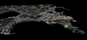
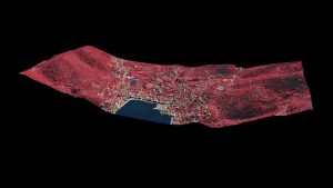
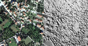
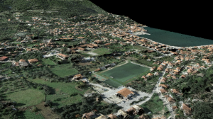
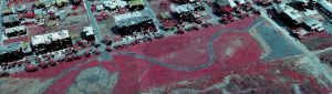
3D reconstruction of complex urban scenes using aerial imagery
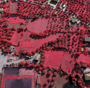
The constant technological evolution in Computer Vision enabled the development of new techniques which in conjunction with the use of Unmanned Aerial Vehicles (UAVs) may extract high quality photogrammetric products for several applications. Dense Image Matching (DIM) is a Computer Vision technique that can generate a dense 3D point cloud of an area or object. The use of UAV systems and DIM/Multi View Stereo(MVS) techniques is not only a flexible and attractive solution to produce accurate and high qualitative photogrammetric results but also is a major contribution to cost effectiveness. The use of the two rapidly evolving approaches, the UAVs+DIM, can extract accurate photogrammetric products such 3D point clouds and orthoimages for several applications such as geometric documentation of a cultural heritage site, cadastre, urban studies, 3D modeling, change detection, emergency response, critical infrastructure monitoring, etc. The main advantages of the use of the UAVs are 1) high navigation accuracy, 2) high-risk flight potentials, 3) low operational cost, 4) ability to integrate several type of sensors (e.g. hyperspectral, pushbroom), 5) large scale images and 6) high overlapping of collected images. The aforementioned characteristics offer applicability to a wide range of applications providing accuracy, economy, rapidity and automation during operation. In this context a 3D reconstruction of several complex urban scenes was performed using aerial imagery through Erdas Imagine/Imagine UAV software.
Further reading:
- Charalampopoulou, V., Maltezos, E., Bliziotis, D., Manesis, C., 2017. Automated change detection of urban objects and development of a web application. Hexagon (HXGN live 2017), Las Vegas, USA.
- Μαλτέζος Ε., Χαραλαμποπούλου, B., 2016 Σύγχρονες τεχνικές χαρτογράφησης μέσω του Imagine UAV-Erdas Imagine. Διημερίδα «Μη επανδρωμένα Εναέρια Συστήματα (UAS) και Χαρτογράφηση. Ο σύγχρονος τρόπος αποτύπωσης, καταγραφής και τεκμηρίωσης» Π.Σ.Δ.Α.Τ.Μ.
- Maltezos, E., Charalampopoulou, V., 2016. Reconstruction of Urban Scenes using the IMAGINE UAV/ERDAS IMAGINE TOOL. 5th International Workshop on 3D Cadastres.
- Maltezos, E., Skitsas, M., Charalambous, E., Koutras, N., Bliziotis, D., Themistocleous, K., 2016. Critical infrastructure monitoring using UAV imagery. SPIE Proceedings, Volume 9688.
- Μαλτέζος Ε., Μπληζιώτης, Δ., Μάνεσης, Χ., Χαραλαμποπούλου, Β., Ροβίθης, Ε., Κίρτας, Ε., Μάκρα, Κ., Σαββαίδης, Α., Καινοτόμο πολυπαραμετρικό δίκτυο παρακολούθησης παραμορφώσεων & σεισμικής κίνησης σε πολεοδομικά συγκροτήματα με έντονα φαινόμενα εδαφικών καθιζήσεων (indes-musa): Αυτόματη ανίχνευση μεταβολών μέσω ορθοεικόνων και νεφώνν σημείων.ΑΤΜ, 227.
- Maltezos, E., Charalampopoulou, B., Bliziotis, D., Manesis, C.., 2015. INnovative multi-sensor network for DEformation and Seismic Monitoring of Urban Subsidence-prone Areas (INDES MUSA) – Change detection using LiDAR point clouds and orthoimages. European Association of Remote Sensing Companies (EARSC) (https://earsc-portal.eu/pages/viewpage.action?pageId=34868014)