M.App Enterprise
M.App Enterprise engages the “Monitor – Evaluate – Act” paradigm. The platform allows you to easily monitor real-world changes, evaluate the impact, and act on the results. M.App Enterprise provides a unified geospatial enterprise platform that enables customers and partners to configure vertical solutions for their markets and industry segments.
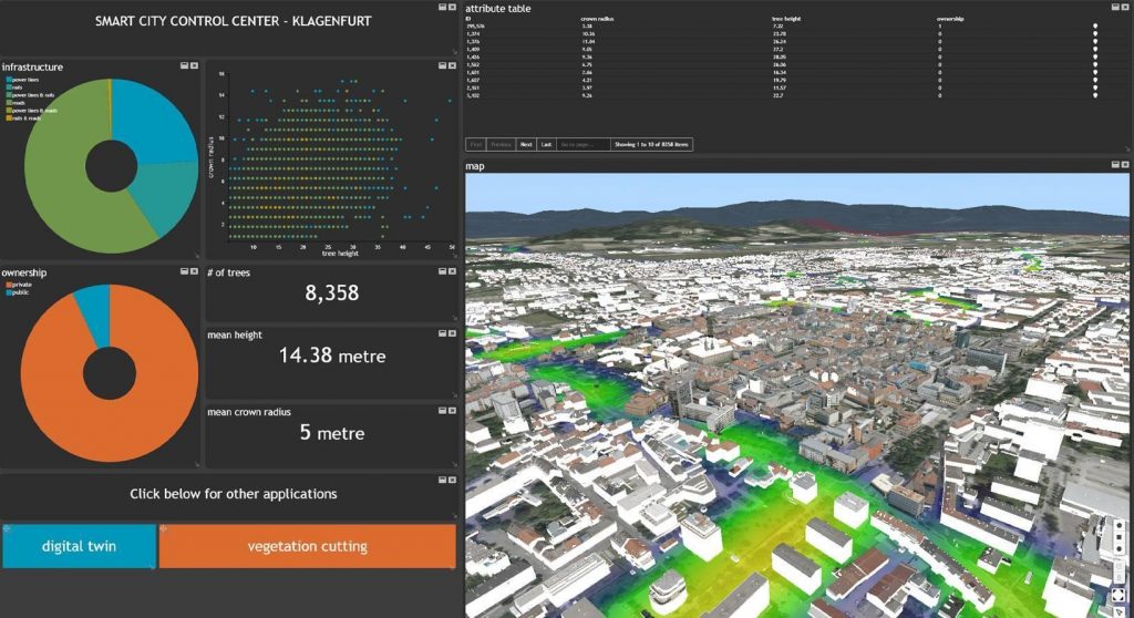
M.App Enterprise lets you smartly monitor infrastructure, traffic, land parcels, and any assets by processing all your sensor, weather, and operational data in a single platform. Leverage machine learning algorithms, visualize the results in 2D and 3D in interactive dashboards, and set up workflows for fieldworkers to capture information on mobile devices.
Key Features
- The desktop client provides a full set of GIS functionality designed for semi-professional users.
- The browser client delivers a map view in 2D and 3D, displaying spatio-temporal analytics.
- Access the platform from anywhere with the native mobile application, even in areas without internet access.
- Customize off-the-shelf apps by using APIs or SDKs.
Capabilities
- Build Rich Client Web-based and Mobile Apps
Configure Smart M.Apps in 2D and 3D, integrated with a set of predefined BI widgets. Access from anywhere with the mobile application, even in areas without internet access. - Connect to Any Spatial Data Source
Connect to your data in its native format – no conversion necessary. Support for file-based data, web services, databases, ERP Systems, and more. - Set up Business Workflows
Create workflows that run daily in the enterprise environment. Implement rules for feature-level access control, data validation, and integration into other systems. - Geoprocessing Engine
Run spatial models with hundreds of functions, analytical routines and algorithms, including machine learning algorithms. - Administer Role-Based Access
Administrators can assign roles, build and customize apps, and view statistics. User management is available out of the box or can integrate with your existing authentication system.
For more information please contact us
Contact person:
Stavros Chlorokostas
Surveying Engineer NTUA, Hexagon Geospatial Solutions Technical Support
![]() s.chlorokostas@geosystems-hellas.gr
s.chlorokostas@geosystems-hellas.gr
![]() +30 2102846144-145
+30 2102846144-145