IMAGE STATION
ImageStation® is specially designed for large-scale photogrammetry processes as well as professionals who produce maps and must convert large amounts of raw spatial information into easy-to-use and exploitable information.
ImageStation enables digital photogrammetry production workflows, including project creation, orientation and triangulation from aerial and satellite imagery. It also provides stereo GIS feature collection and editing and digital terrain model (DTM) collection and editing, as well as orthophoto production and editing. ImageStation is specially designed for high-volume photogrammetry and production mapping customers who need to move large quantities of raw spatial information to an actionable or exploitable format.
The ImageStation software suite is offered in five component applications to allow customizing a solution to meet your specific production requirements.
Project and Data Management:
- ImageStation Photogrammetric Manager (ISPM) – Provides project setup and data management tools for photogrammetric production workflows, including automatic interior orientation, import of aerial frame, ADS line scanner, UAV, and satellite imagery, import/export of photogrammetric data, archive/restore projects, and more.
- ImageStation Image Formatter (ISIF) – Provides efficient, multi-threaded, 64-bit, local and distributed batch image reformatting, on-the-fly overview generation, and application of LUTs.
- HTCondor for Hexagon Geospatial – Provides simplified installation and configuration of the free open source HTCondor distributed processing system from the University of Wisconsin-Madison.
Orientation and Triangulation:
- ImageStation Automatic Triangulation (ISAT) – Provides fully automatic, high performance and high capacity aerial triangulation, including GPS/INS data processing, seamless POSEO support, camera calibration, graphical error analysis, efficient multi-photo point measurement with automatic point transfer, adjustment of satellite RPCs, and more.
- ImageStation Satellite Triangulation (ISST) – Provides simultaneous bundle adjustment of selected satellite sensors based on ephemeris data and orbital models.
Feature Collection:
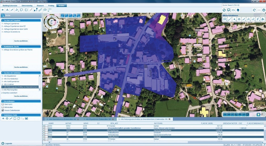
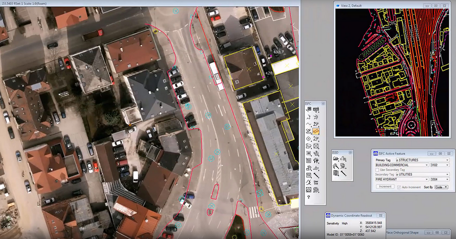
- ImageStation Feature Collection (ISFC) – Provides interactive collection and editing of 2D and 3D map feature data and attributes in MicroStation CONNECT, completely integrated with ImageStation Stereo Display and ImageStation DTM Collection.
- ImageStation Stereo Display (ISSD) – Provides stereo image and vector display, photogrammetrically accurate 3D cursor tracking, on-the-fly image enhancement, smooth roam, and digital zoom in MicroStation CONNECT, completely integrated with ImageStation Feature Collection and ImageStation DTM Collection.
- ImageStation Stereo for GeoMedia (ISSG) – Provides stereo image and vector display, photogrammetrically accurate 3D cursor tracking, interactive collection and editing of 2D and 3D feature data and attributes, on- the-fly image enhancement, smooth roam, and digital zoom in the GeoMedia GIS environment, completely integrated with ImageStation DTM for GeoMedia.
- ImageStation Stereo Viewer for GeoMedia (ISSV) – Provides stereo image and vector viewing, on-the-fly image enhancement, smooth roam, digital zoom, and 3D linear and area measurement in a separate (non-map) window in the GeoMedia GIS environment (no feature collection).
Digital Terrain Model generation:
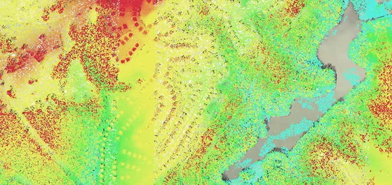
- ImageStation DTM Collection (ISDC) – Automatic collection and processing of DTM, production of Triangulated Irregular Network (TIN) and contour lines.
- ImageStation DTM for GeoMedia (ISDG) – Transformation of terrain data into surface files for photogrammetric applications.
- ImageStation Automatic Elevations (ISAE) – Automatic generation of Digital Terrain Models (DTMs) using aerial photos or satellite images.
- ImageStation Automatic Elevations DSM (ISAD) – A superset of ISAE that adds 64-bit dense point cloud and raster digital surface model (DSM) and raster generation from aerial frame and satellite stereo imagery using Semi-Global Matching (SGM) and local or distributed multi-threaded processing.
- ImageStation DTMQue (ISDQ) – Βatch processing for transformation of DTM format, reprojection in other reference coordinate systems, merging, clip e.t.c.
Orthophoto Generation:
- ImageStation OrthoPro (ISOP) – Provides a complete orthomosaic solution including orthorectification, true ortho capability, adaptive radiometric enhancements (dodging, dehaze, ADRA), automatic seam line generation, semi-automated review and editing of seamlines, tone balancing, mosaicking, and geometric accuracy assessment.
- ImageStation PixelQue (ISPQ) – Provides systematic quality review, mark up of problem areas, queued editing of marked problems, and enhancement of ortho mosaics.
Newest Release – ImageStation 2022:
Part of the new Power Portfolio 2022, ImageStation 2022 (version 16.7) comes with many enhancements and fixes:
- Compatibility with GeoMedia 2022 and its underlying core components, including Common Raster Platform and Common Coordinate Systems
- Replacement of Microstation V8i by MicroStation CONNECT
- Various new commands, More editing options, Support for more file formats and more
For more information please contact us
Contact person:
Katerina Fotiou
Surveying Engineer NTUA, Photogrammetry Expert, Key Account Manager
![]() c.fotiou@geosystems-hellas.gr
c.fotiou@geosystems-hellas.gr
![]() +30 2102846144-145
+30 2102846144-145