The purpose of the PROION project is the development of a platform for the continuous monitoring of high-priority infrastructures (public infrastructure, dams, bridges, etc.) which are located in a particularly active areain terms of tectonics and seismicity. Monitoring the aforementioned infrastructures is based on the combination ofin-situ and remote sensing measurements, fuzzy logic network methods, and machine learning algorithms to generate an innovative decision-making and decision-support tool. More specifically, the measurements derivingfrom three-axis accelerometers, Global Navigation Satellite System (GNSS) receivers and Persistent Scatterer Interferometry are imported into the platform. The measurements will be validated using high-accuracy referencere presentations arising from data acquired by Terrestrial Laser Scanning (TLS) surveys and Unmanned Aerial Vehicles(UAV) campaigns and subsequently, deformation maps will be generated. Intelligent data analysis methods will contribute to making decisions on the current as well as the future state of the infrastructure.
The aim of CO-PROTECT is to make Greece a technologically emerging power in the response to natural disasters, at a time when climate change, with the collateral pressure of the pandemic, is a major issue, affecting human existence and well-being. The effects of climate change are creating an upsurge in floods and extreme weather events combined with drought and forest fires; deforestation from fires is creating landslides and land degradation due to extreme weather events, etc. Moreover, in seismically active regions, such as our country, the pressure increases. All of the above is reflected in the built environment where most of the inhabitants of European countries live and the critical infrastructure related to utility networks, ports, airports, hospitals, etc. The imperative of the Paris Agreement and the climate policy “2050 long-term strategy” guides us in the creation of advanced products/solutions, making Greece, through the GCC and the “CO-PROTECT” project, a strong industrial player of ready-made solutions with efficient results.
The SPACE project, as an outcome of the Greek Cooperative Formation of Space Technologies and Applications (Si-Cluster), focuses on earth observation data management combined with the use of space technologies and Artificial Intelligence models to develop new applications that will help manage environmental crisis and political protection. More specifically, the main objectives of the project are the development of a system for monitoring and modeling atmospheric gusts, management of port security, and monitoring various crop parameters from UAV arrays to develop an intelligent sustainable agriculture management system.
The complexity of modern urban environment requires the ability to handle a great number of various types of data “spatially” – with spatial reference and topological structure. Public demand for good urban governance (related to economy, environment, and/or social issues) and efficiency improvement has brought the need for more sophisticated Systems; as cities expand vertically a 3d topological structure of LISs (or 3d-GIS) is already used. This project will develop an advanced 5D Multi-Purpose LIS (Land information System), based on existing 3d packages (traded by the two participating enterprises) for integrating and managing various types of information (financial, architectural, topographical, cadastral, valuation, engineering, ownership, etc.) from governmental, regional and local databases at 3d spatial dimensions + time + scale. The system will allow represen-tations and analysis of real estate properties and manmade features in three physical dimensions (X,Y,Z), through time (planning phase, development phase, registration phase, modification phase, and so on) and at varying scales (level of detail). The proposed innovative system will focus on creating add-ons; the Israeli part will develop the prototype in the web (in the Cloud) while the Greek part will develop add-ons for desktop applications.
SEN4RUS
The challenge of SEN4RUS is to develop a set of indicators by exploiting the Copernicus Sentinels in support of urban and peri-urban planning. Three representative Russian cities with different characteristics are the case studies. SEN4RUS will extend the GEOURBAN indicators to new applications, i.e. energy, urban climate. The development of a Web-based Information System (WIS) will evaluate and provide the indicators in a user-friendly form that allows direct implementation into planning procedures. SEN4RUS bridges the gap between Earth Observation (EO) scientists and urban planners focusing on the urban structure and the urban environmental quality.
Cultural Heritage
METEORA
The 5dMeteora project aims at the documentation and digitization of a part of the Archeological Site of Meteora. Particularly, the main study area consists of two inaccessible rocks: the rock of St. Modestos (‘Modi’) and the rock of the Chain of Apostle Peter (‘Alyssos’). At the top of both rocks, there are ruins of old Monasteries. Within this project, the Monastery of the St. Modestos is being digitally reconstructed; it is visualized both via the visualization system of the platform and through the Augmented Reality app. The choice of these two rocks lies in the existence of important findings, in the unexplored – until today – establishment and evolution of their monastic community as well as in the special topography and geological morphology. Apart from Modi and Alyssos, the study area includes the majority of monuments in the Holy Site of Meteora, including the six active Monasteries, the Pyxari rock, as well as some hermitages and other cultural heritage sites in the wider area.
STABLE
The STABLE project is addressing risk maps of Cultural Heritage (CH) at a medium scale, such as a block of buildings and large structures, to derive similar damage maps, by collecting information before the event occurs and addressing damage forecast for seismic movements which have an impact on the structural stability of the CH. The introduction of a strategy and the selection of the most efficient methods and tools for harmonization of data, criteria, and indicators to be addressed for tracking the impact of environmental changes on tangible cultural heritage assets, buildings, and monuments, including structural deterioration processes at a city/village scale, will be achieved. This valuable information needs to be complemented, calibrated, and tested with ground data (e.g., geotechnical information), site scale monitoring (e.g., ground monitoring stations, laser scanners, etc.), and risk forecasting models (related to earthquakes) to derive end-user-driven products like deformation maps, vulnerability, and damage maps. The project focuses on the design and development of an IT service platform, combining advanced satellite technologies with existing ground-based data and risk forecasting modeling for the long term and continuing monitoring and updating of structural stability of the architectural heritage, particularly historical centers affected by geo-hazards.
RESEARCH (REmote SEnsing techniques for ARCHaeology) will test new risk assessment methodology, by examining soil erosion, land movement, and land use change threatening archaeological sites. The project uses an integrated system of documentation and research in the fields of archaeology and environmental studies, combining advanced remote sensing technologies with GIS applications for the mapping and long-term monitoring of archaeological heritage. The project addresses the design and development of a multi-task thematic platform, that will be a new affordable tool for authorities in charge of CH preservation, to monitor the degradation process, enable preventive maintenance, and reduce restoration costs.
D^2EPC aims to set the grounds for the next generation of dynamic Energy Performance Certificates (EPCs) for buildings. The proposed framework sets its foundations on the smart-readiness level of the buildings and the corresponding data collection infrastructure and management systems. It is fed by operational data and adopts the ‘digital twin’ concept to advance Building Information Modelling, calculate a novel set of energy, environmental, financial and human comfort/ wellbeing indicators, and through them the EPC classification of the building in question.
PEARLS
As an active key actor in the spatial planning and social innovation arena for Renewable Energy Landscapes (REL), PEARLS project will reinforce the population’s commitment to secure, clean and efficient energy. REL are regarded as spaces where renewable energies change the population’s relationship with energy and their landscape perception. Despite all efforts, resistance to REL lingers in Europe, while the reasons for strong social acceptance in Mediterranean and South American countries are still unknown. PEARLS main goal is to develop applied knowledge through questions about how to increase public engagement in the behalf of sustainable renewable energy system through planning processes. Its results will transform policy initiatives and strategic interventions with the population, in places where energy resources are relevant and local communities are disadvantaged from the opportunities that networking offers.
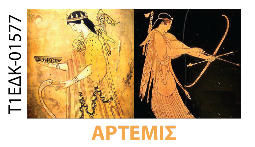
The ARTEMIS project aims at creating a multi-parameter service for the processing and diffusion of satellite and other data on an online platform related to the quality, health and sustainable development of economic forests and specific chestnut forests. As a region of interest, we place the forests of Thessaly and specifically the area of the Municipality of Mouzaki. The forests of the Mediterranean chestnut have been “degraded” in Thessaly, although it is a lucrative crop. Unfortunately, the long-term lack of planning for alternative crops and the lack of policies to support the mountain populations that forced young people to move to urban centers have led to brown cultivation in Thessaly and especially the forests of Mouzaki, almost in a state of abandonment. The development of practices and algorithms that will certify health and provide continuous monitoring will help increase primary production, but at the same time will ensure the preservation of biodiversity and therefore quality production. The project will address mainly the existing threats to forest health in specific areas, which are mainly caused by biotic factors (insects, diseases, etc.), resulting in their degradation and often the mortality of forest species and its destruction of production.
Disaster Response – Nature
EPIPELAGIC
The EPIPELAGIC project is a Bilateral and Multilateral Cooperation project between Greece and China focused on monitoring coastal areas. The project’s main goal is to address and mitigate the effects of climate change and natural disasters by providing methodologies and tools that use time series of Earth Observation satellite data in combination with other auxiliary data and field measurements. The main objective is to create an electronic platform and a decision support platform to monitor and evaluate significant changes that can be associated with natural and anthropogenic hazards, including land use change, shoreline changes over time, soil erosion, ground deformation, and sea and groundwater level monitoring. EPIPELAGIC aims at demonstrating the capabilities of satellite synergistic observations analysis to evaluate suitable indicators. The research activities to be carried out will provide sustainable support to local culture, society, economy, and environment in both countries.
The integrated nature of the proposed monitoring scheme will be provided by a combination of Airborne Lidar missions, mobile GNSS stations, a tide gauge and water level sensors for ground subsidence measurements complemented by permanent accelerographic and GNSS stations for monitoring seismic motion. The above multi-sensor scheme will be deployed as an innovative pilot study, based on available means, in properly selected urban sites in Greece and China. The Greek site under investigation is located in the region of Kalochori close to Thessaloniki in North Greece, presenting great scientific and monitoring interest related to the examined natural hazards, thereby in agreement with the general objectives of the proposed project. Besides monitoring and data processing, soil subsidence and seismic motion will be investigated by means of pertinent methods of analysis that will be developed and adapted in an urban-scale sense aiming at a better understanding of the investigated hazard sources as affected by the urban environment. Both recorded data and analysis predictions will be integrated, combined and implemented towards the development of a research tool that will be made readily-available and accessible to the scientific community and local/national decision-making authorities during the project through a properly designed Web platform. The project is expected to have a direct benefit to the participating enterprises and research teams based on a profitable technical know-how or/and scientific personnel exchange between the two countries.
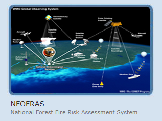
NFOFRAS
The National Forest Fires Risk Assessment System (NFOFRAS) is an ongoing collaborative research program for the development and continuous upgrading of a unified assessment system which estimates the annual dryness of forest biomass based on climatic behavior of the atmosphere all year round and in particular in the “wet climatic period” . The success of the system in full operational-functional status involves three phases.
SUPERSITE
The research objectives of the Greek supersite are:
-Long term monitoring of the area for mapping the crustal deformation and stress-strain regime, including time-varying patterns in an area that holds the highest seismicity in Europe.
-Perform updated seismicity relocations for the areas of interest, using the introduced calibrated crustal/upper models.
-Exploitation of the available datasets (existing and new) to obtain reliable empirical estimates of source, path and site effects for seismic motions in the Supersite area.
-Efficient fusion of the acquired earth and space observations in order to better monitor and understand the hazard sources.
-Exploitation of ground and satellite information to assess the risk in the Supersite area and achieve Disaster Risk Reduction and Quick Resilience.
Waste Management
CompOlive
The CompOlive project aims at developing an integrated technological product – management system and application that includes software development, logistics infrastructure and services. CompOlive using advanced remote sensing products, innovative digital technologies and know-how in the field of composting, will contribute and allow the efficient treatment and utilization of waste oil production materials in the field (on-farm). The philosophy of the project is simple (Figure 1) and essentially aims at achieving a circular economy in the agri-food sector, with emphasis on olive production, while making composting in the field as a service (composting on-farm as a service) economically viable and viable.
ACRITAS aimed at the research, design, development and validation of space-based integrated applications for surveillance and monitoring through advanced multi-sensor data fusion technologies. Special emphasis is put on the integrated use of space-related technologies (i.e., Earth Observation (GMES), Satellite Communications (SatCom), and Satellite Navigation (GNSS)), and their fusion with available terrestrial in-situ assets for key application domains, such as: Border Surveillance, Critical Energy Infrastructure Monitoring, Coastal Environmental Monitoring, and Agricultural Monitoring.
BLENDED
BLENDED, a European Space Agency funded research project led by Space Applications Services is investigating the application of technologies that enable the secure, valuable and efficient collaboration of data and algorithms. The project will be applying the Inter-Planetary File System (IPFS), encryption and blockchain smart contract technologies to prototype a peer-to-peer, decentralised Machine Learning training platform for space data.