COSMO-SkyMed
The COSMO-Skymed system consists of four radar satellites for Earth observation. Its purpose is to monitor and provide data on a global scale for commercial and scientific purposes and also provides the possibility of emergency prevention (environmental risk management, defense and national security).
The COSMO-Skymed system is at the forefront of global technology and uses high-resolution radar for observing the Earth during the day or night, regardless of weather conditions. The fourth satellite was launched on November 5, 2010, and the system is now fully operated.
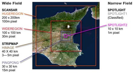
Multi-polarimetric and multi-temporal capabilities allow it to be used in a wide range of applications – civil and military. The sensor can capture images in different functions such as:
- ScanSar (wide coverage with moderate to low spatial resolution)
- Stripmap (medium coverage with high resolution)
- Spotlight (small coverage with metric resolution)
Main Applications:
- Awareness of situations in the maritime sector (tracking of ships, detection of oil spills, etc.)
- Defense and security applications (defense & intelligence applications)
- Thematic mapping (change detection analyzes, environmental applications, etc.)
- Apps requiring immediate response (flood mapping, natural disasters, etc.)
- Soil stability analysis (monitoring of volcanoes, land settlements, etc.)
More about COSMO-SkyMed can be found here.
For more information please contact us
Contact person:
Άννα Παπαδήμα
Surveying Engineer NTUA, Junior Analyst
email: a.papadima@geosystems-hellas.gr
![]() tel: +30 2102846144-145
tel: +30 2102846144-145