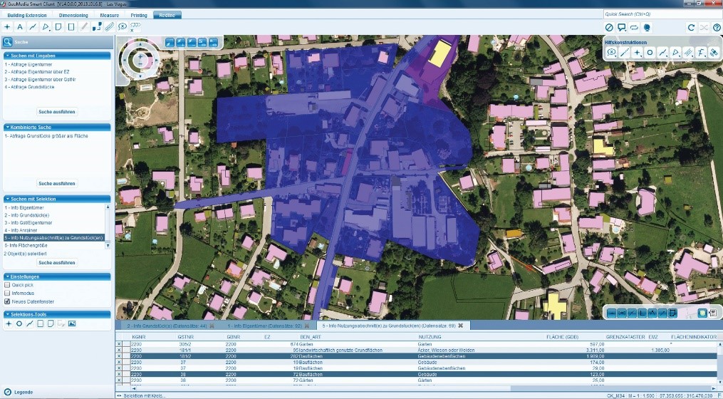
GEOMEDIA SMART CLIENT
GeoMedia® Smart Client is a GIS workflow management system that connects tasks and dependencies across different roles in a process, and dynamically configures to reflect a user’s role and specific workflow steps. End users are able to use advanced geospatial functionality via simple-to-use map-based tools, disentangling them from nonessential tasks and focusing their time on their area of expertise. GeoMedia Smart Client completes your existing desktop GIS by opening your geospatial assets to a larger audience. Geospatial datasets and maps produced from a desktop GIS feed a Smart GIS with content while leveraging the advantages of a web GIS to deliver light and application-specific solutions to more users.
FEATURES
- Advanced geospatial data entry method that reduces the volume of data transferred from the server.
- User friendly interface that reduces the cost of training new users.
- Communication between client and application is done entirely through Web Services using Simple Object Access Protocol (SOAP) technology. An installation supports an unlimited number of users in the office and in the field.
- Oracle, Microsoft SQL Server and PostgreSQL support.
PRODUCT TIERS
GeoMedia Smart Client is available in three product tiers to complement a broad range of customers – from a small business with few users doing simple vector-editing to large, multi-disciplinary environments supporting multiple business workflows across various departments.
GeoMedia Smart Client Essentials
Organizations can provide high-end vector redlining functionality plus support for an unlimited number of users to display raster and vector maps, analyze and query data, print, and utilize measurement and dimensioning functions. Vector database support includes the direct capability to read Oracle (10g and higher), Microsoft SQL Server (2008 and higher), and PostgreSQL (9.0 and higher). Raster format support is also available and includes TIFF, GeoTIFF, JPG, and PNG for raster data. Advanced client and server caching are provided for raster and vector data to ensure high performance – even in a disconnected mode.
GeoMedia Smart Client Advantage
This tier of GeoMedia Smart Client includes Workflow Manager and has a runtime module that enables customers to utilize predefined business process workflows, edit attributes or capture and change spatial data on the web client. It is able to push changes back to the server database, including Oracle (10g and higher), Microsoft SQL Server (2008 and higher), and PostgreSQL (9.0 and higher).
GeoMedia Smart Client Professional
For customers that want to define their own workflows or modify existing ones, this tier of GeoMedia Smart Client includes Workflow Manager – Editor. This capability enables an organization to develop its own workflows or revise the structure, process, and forms of current ones. Furthermore, organizations can provide and information and insight to more stakeholders and interested parties by delivering simple maps configured directly from GeoMedia Smart Client to a web browser and public-facing websites.
For more information please contact us
Contact person:
Christina Lydia Valdesera
Geographer HUA, Technical Sales Manager
![]() l.valdessera@geosystems-hellas.gr
l.valdessera@geosystems-hellas.gr
![]() +30 2102846144-145
+30 2102846144-145