Skip to content
  • Home
  • The Company
    • Profile
    • Our Team
    • Associates
    • Publications
    • Careers
  • Products
    • Hexagon Geospatial software
      • Remote Sensing
        • ERDAS IMAGINE
        • ERDAS IMAGINE Add-ons
        • ATCOR Workflow
        • IMAGINE NoClouds
        • Sentinel Made Simple
        • ER Mapper
      • Photogrammetry
        • IMAGINE PHOTOGRAMMETRY
        • IMAGE STATION
        • IMAGINE UAV
        • ERDAS Extensions for ArcGIS
      • GIS and Mapping
        • GEOMEDIA
        • GeoMedia Add-ons
        • GEOMEDIA SMART CLIENT
      • Web GIS
        • GEOMEDIA WebMap
        • GEOSPATIAL Portal
        • GEOSPATIAL SDI
      • Data Management
        • ERDAS APOLLO
        • ECW Compression
        • GeoCompressor
      • Solutions
        • HxGN Mass Transit
        • HxGN Smart Census
        • M.App X
        • Mobile Alert
        • SafeHaul
        • HxGN SafeRoads
      • Platforms
        • Luciad Portfolio
        • M.App Enterprise
      • Technical Support
    • Leica Geosystems sensors
      • Sensors
        • Leica RCD30
        • Leica RCD30 for UAV
        • Leica RCD30 Oblique
        • Leica RC30
        • Leica ADS80 Airborne Digital Sensor
      • Lidar Sensors
        • Leica RCD105 Digital Frame Camera
        • Leica ALS70 Airborne Laser Scanner
        • Leica ALS60 Airborne Laser Scanner
        • Leica ALS Corridor Mapper
      • Leica Software
        • Leica ORIMA
        • Leica XPro
        • Leica FCMS
        • Leica IPAS Freebird
        • Leica FPES
        • Leica MissionPro
      • Scanners
        • Leica DSW700V
    • Satellite Imagery
      • Optical data
        • Planet
        • Skywatch
      • SAR data
        • COSMO-SkyMed
  • Projects-Services
  • Trainings-Conferences
  • R&D
    • Completed R&D projects
    • Ongoing R&D projects
  • Contact
  • English
    • Ελληνικά
    • English
  • ESPA
Geosystems Hellas S.A.
 
  • Home
  • The Company
    • Profile
    • Our Team
    • Associates
    • Publications
    • Careers
  • Products
    • Hexagon Geospatial software
      • Remote Sensing
        • ERDAS IMAGINE
        • ERDAS IMAGINE Add-ons
        • ATCOR Workflow
        • IMAGINE NoClouds
        • Sentinel Made Simple
        • ER Mapper
      • Photogrammetry
        • IMAGINE PHOTOGRAMMETRY
        • IMAGE STATION
        • IMAGINE UAV
        • ERDAS Extensions for ArcGIS
      • GIS and Mapping
        • GEOMEDIA
        • GeoMedia Add-ons
        • GEOMEDIA SMART CLIENT
      • Web GIS
        • GEOMEDIA WebMap
        • GEOSPATIAL Portal
        • GEOSPATIAL SDI
      • Data Management
        • ERDAS APOLLO
        • ECW Compression
        • GeoCompressor
      • Solutions
        • HxGN Mass Transit
        • HxGN Smart Census
        • M.App X
        • Mobile Alert
        • SafeHaul
        • HxGN SafeRoads
      • Platforms
        • Luciad Portfolio
        • M.App Enterprise
      • Technical Support
    • Leica Geosystems sensors
      • Sensors
        • Leica RCD30
        • Leica RCD30 for UAV
        • Leica RCD30 Oblique
        • Leica RC30
        • Leica ADS80 Airborne Digital Sensor
      • Lidar Sensors
        • Leica RCD105 Digital Frame Camera
        • Leica ALS70 Airborne Laser Scanner
        • Leica ALS60 Airborne Laser Scanner
        • Leica ALS Corridor Mapper
      • Leica Software
        • Leica ORIMA
        • Leica XPro
        • Leica FCMS
        • Leica IPAS Freebird
        • Leica FPES
        • Leica MissionPro
      • Scanners
        • Leica DSW700V
    • Satellite Imagery
      • Optical data
        • Planet
        • Skywatch
      • SAR data
        • COSMO-SkyMed
  • Projects-Services
  • Trainings-Conferences
  • R&D
    • Completed R&D projects
    • Ongoing R&D projects
  • Contact
  • English
    • Ελληνικά
    • English
  • ESPA
Category: <span>Remote Sensing</span>
Home Products Hexagon Geospatial software Archive for category "Remote Sensing"

Category: Remote Sensing

New Remote Sensing and GIS for Education Programs

New Remote Sensing and GIS for Education Programs

23 December 2021 23 December 2021

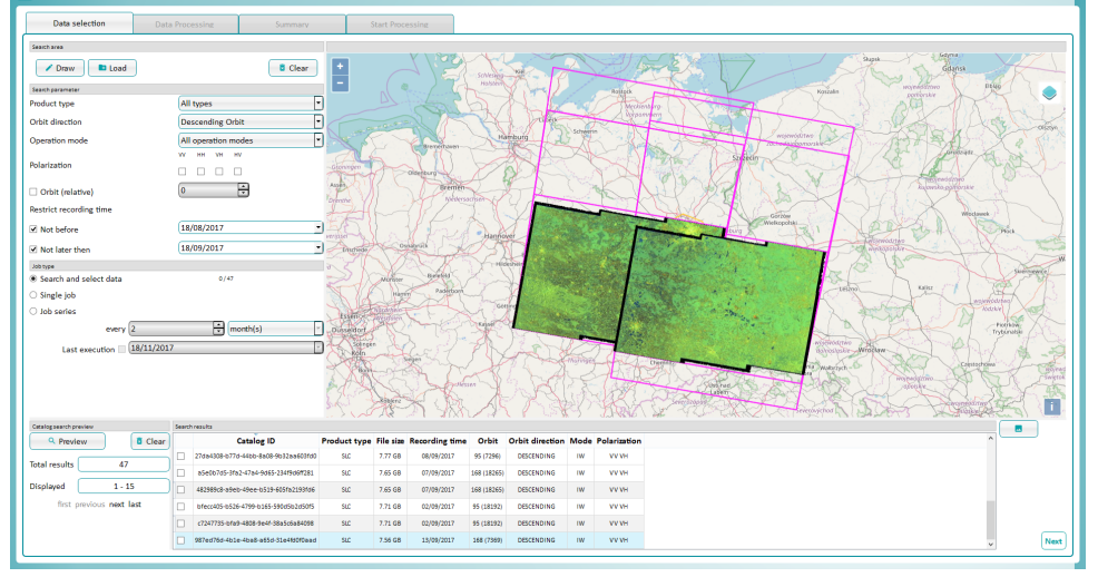
NEW SOFTWARE SOLUTIONS 2022, FOR UNIVERSITIES AND INSTITUTES «REMOTE SENSING, PHOTOGRAMMETRY & GEOGRAPHIC INFORMATION SYSTEMS» …

Περισσότερα..."New Remote Sensing and GIS for Education Programs"
Sentinel Made Simple

Sentinel Made Simple

27 May 2020 22 September 2021

Sentinel Made Simple is a stand-alone tool for the downloading and processing of Sentinel-1 and …

Περισσότερα..."Sentinel Made Simple"
ATCOR Workflow

ATCOR Workflow

27 May 2020 22 September 2021

ATCOR Workflow (ATCOR stands for ATmospheric CORrection) is a software add-on for ERDAS IMAGINE®, providing …

Περισσότερα..."ATCOR Workflow"
IMAGINE NoClouds

IMAGINE NoClouds

27 May 2020 22 September 2021

IMAGINE NoClouds software is an add-on module for ERDAS IMAGINE that offers processes to deal …

Περισσότερα..."IMAGINE NoClouds"
ERDAS IMAGINE

ERDAS IMAGINE

21 March 2018 7 December 2021

ERDAS IMAGINE is offered within the Producer Suite of HEXAGON GEOSPATIAL. It empowers the user …

Περισσότερα..."ERDAS IMAGINE"
IMAGINE UAV

IMAGINE UAV

15 March 2018 22 September 2021

IMAGINE UAV is the ERDAS IMAGINE add-on module for the automated photogrammetric processing of UAV …

Περισσότερα..."IMAGINE UAV"

Company Brochure

  • GSH Brochure 2021

ISO certifications

ISO 9001

ISO 22301:2019

ISO 27001:2013


Recent Posts

  • Geosystems Hellas supports the 4ᵗʰ Congress of Geographical Information Systems and Spatial Analysis in Agriculture and Environment
  • Geosystems Hellas participates in ESA Living Planet Symposium 2022 in Bonn
  • ERDAS Extension 2020 SP2 now supports ArcGIS®
May 2022
M T W T F S S
 1
2345678
9101112131415
16171819202122
23242526272829
3031  
« Mar    
  • Facebook
  • Twitter
  • Linkedin
  • Instagram

Contact

225 Imittou Str., GR 116 32, Athens

  Branch: HMU-Building K34, Estavromenos,
  GR 714 10, Heraklion, Crete

+30 210 2846144-145

mail@geoystems-hellas.gr

Categories

Follow us

Back to Top
Powered by Fluida & WordPress.
Skip to content
Open toolbar

Accessibility Tools

  • Increase Text
  • Decrease Text
  • Grayscale
  • High Contrast
  • Negative Contrast
  • Light Background
  • Links Underline
  • Readable Font
  • Reset