Skip to content
  • The Company
    • Profile
    • Our Team
    • Associates
    • Publications
  • Products
    • Hexagon Geospatial software
      • Remote Sensing
        • ERDAS IMAGINE
        • Atcor
        • IMAGINE NoClouds
        • Sentinel Made Simple
      • Photogrammetry
        • IMAGINE PHOTOGRAMMETRY
        • IMAGE STATION
        • IMAGINE UAV
      • GIS and Mapping
        • GEOMEDIA
        • GEOMEDIA SMART CLIENT
      • Web GIS
        • GEOMEDIA WebMap
        • GEOSPATIAL Portal
        • GEOSPATIAL SDI
      • Data Management
        • ERDAS APOLLO
        • ECW Compression
        • GeoCompressor
      • Technical Support
    • Leica Geosystems sensors
      • Sensors
        • Leica RCD30
        • Leica RCD30 for UAV
        • Leica RCD30 Oblique
        • Leica RC30
        • Leica ADS80 Airborne Digital Sensor
        • Leica ALS70 Airborne Laser Scanner
      • Lidar Sensors
        • Leica RCD105 Digital Frame Camera
        • Leica ALS70 Airborne Laser Scanner
        • Leica ALS60 Airborne Laser Scanner
        • Leica ALS Corridor Mapper
      • Leica Software
        • Leica ORIMA
        • Leica XPro
        • Leica FCMS
        • Leica IPAS Freebird
        • Leica FPES
        • Leica MissionPro
    • Satellite Imagery
      • Optical data
        • Planet
        • Skywatch
      • SAR data
        • COSMO-SkyMed
    • Smart M.Apps
  • Projects-Services
  • Trainings-Conferences
  • R&D
    • Completed R&D projects
    • Ongoing R&D projects
  • Contact
  • English
    • Ελληνικά
    • English
Geosystems Hellas S.A.
FacebookTwitterLinkedin
 
  • The Company
    • Profile
    • Our Team
    • Associates
    • Publications
  • Products
    • Hexagon Geospatial software
      • Remote Sensing
        • ERDAS IMAGINE
        • Atcor
        • IMAGINE NoClouds
        • Sentinel Made Simple
      • Photogrammetry
        • IMAGINE PHOTOGRAMMETRY
        • IMAGE STATION
        • IMAGINE UAV
      • GIS and Mapping
        • GEOMEDIA
        • GEOMEDIA SMART CLIENT
      • Web GIS
        • GEOMEDIA WebMap
        • GEOSPATIAL Portal
        • GEOSPATIAL SDI
      • Data Management
        • ERDAS APOLLO
        • ECW Compression
        • GeoCompressor
      • Technical Support
    • Leica Geosystems sensors
      • Sensors
        • Leica RCD30
        • Leica RCD30 for UAV
        • Leica RCD30 Oblique
        • Leica RC30
        • Leica ADS80 Airborne Digital Sensor
        • Leica ALS70 Airborne Laser Scanner
      • Lidar Sensors
        • Leica RCD105 Digital Frame Camera
        • Leica ALS70 Airborne Laser Scanner
        • Leica ALS60 Airborne Laser Scanner
        • Leica ALS Corridor Mapper
      • Leica Software
        • Leica ORIMA
        • Leica XPro
        • Leica FCMS
        • Leica IPAS Freebird
        • Leica FPES
        • Leica MissionPro
    • Satellite Imagery
      • Optical data
        • Planet
        • Skywatch
      • SAR data
        • COSMO-SkyMed
    • Smart M.Apps
  • Projects-Services
  • Trainings-Conferences
  • R&D
    • Completed R&D projects
    • Ongoing R&D projects
  • Contact
  • English
    • Ελληνικά
    • English
Leica RC30
Home Latest News Leica RC30
Leica RC30

Leica RC30

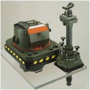
Leica RC series comes first in the preferences of professionals worldwide with hundreds of satisfied customers. Sensors in this series are characterized by high quality and reliability.
Read more..
Leica ALS70 Airborne Laser Scanner
Leica ADS80 Airborne Digital Sensor

Recent Posts

  • Next-Generation PlanetScope Imagery
  • GSH is involved in the ESA-funded project : Synergetic use of Blockchain and Deep Learning for Space Data – BLENDED
  • GSH attends Geomedia 2020 Advanced Training
  • GSH attends M.appX 2020 Training
  • Copernicus Hackathon in Athens 2020
March 2021
M T W T F S S
« Jun    
1234567
891011121314
15161718192021
22232425262728
293031  

Follow us

  • Facebook
  • Twitter
  • Linkedin

Categories