LiDAR and RGB airborne orthophotos coverage and visualization and recognition of archeological findings in Kephissos valley /Phokis
In 2016 the landscape archaeological program “Topographic investigations in the Kephissos valley (Phokis)” started as a joint collaboration of the DAI with the Ephorate of Antiquities of Fthiotida and Evrytania. The integrative collaborative program includes, besides archaeological investigations, aerial imagery (LiDAR, analysis of historical aerial photos), geophysical surveys and geomorphological investigations. In 2018, via a funding from the Fritz Thyssen Foundation, the whole area under consideration around Elateia, Tithorea and Modi (around 145 sq km) was covered with LiDAR and RGB airborne orthophotos, the largest LiDAR coverage of an area up to now in Greece.
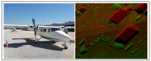
The visualization, recognition and interpretation gave valuable information on new findings of human made structures (urban, fort, man-made and horizontal fields). The orthophotos for the complete AOI were generated after the exploitation of the LiDAR point clouds as the reference DTM. This exploitation maximizes the resulting accuracies as the measured LiDAR points provide the best Ground surface model available. The resulting orthoimages were combined to a merged orthomosaic and then tiled to the 500x500m map sheets. The resulting tiles orthomosaics and LiDAR point clouds were then combined to produce the final RGB-Coloured point clouds, coming again to 500x500m map sheet blocks.
Precision sensing with Lidar technologies is a powerful technology that provides many benefits, including high accuracy, cost savings, real-time monitoring and analysis, and easy integration with the existing infrastructure of an on-site system.
Such large-scale footprinting applications can be used in cities, settlements and critical infrastructures and make them ‘smarter’. In today’s challenges like climate change, extreme weather, traffic congestion, pollution, etc., large-scale three-dimensional (3D) imaging can be extremely useful. The city’s Digital Twin is involved at every level of management, from transportation, emergency or public utility services, or urban planning. It gathers multi-level data sources, such as: buildings, urban infrastructures, IoT data, utilities, businesses, people and vehicle movements, civil protection simulations, etc.
GEOSYSTEMS HELLAS A.E. offers a combination of expertise and knowledge with innovative technologies and forward-looking developments to modernize cities and regions.