Aerial Coverage of the Area of the Sanctuary of Zeus at Mt. Lykaion through ALS/LIDAR and High Resolution Imagery
The geometric documentation of a cultural heritage site is demanding task due to the complex morphology of the objects. The last years, more and more researchers have used new laser technologies and sophisticated computer vision techniques, mainly for terrestrial applications, with a complementary use of land surveying measurements. Although such technologies and processes provide efficiency, they are time-consuming with high cost for big covered areas with difficult accessibility. Aerial laser scanning (ALS/LIDAR) can contribute to the extraction of high-level information from huge cultural heritage sites for both structural and historical purposes.
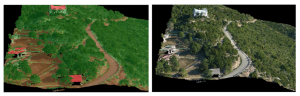
The wider area of the Sanctuary of Zeus at Mountain Lykaion is considered, among others, as one of the most important cultural heritage sites in Greece. This study aims to the aerial coverage of this area, that is, 117. 85 km2, through ALS/LIDAR and RGB high resolution imagery. At first step, the ALS/LIDAR point clouds and the RGB imagery were simultaneously acquired over the area of interest. The adjustment of neighboring ALS/LIDAR strips was firstly performed through strip alignment and then a georeference process using ground control points (GCPs) and check points (CPs) was carried out afterwards. The ALS/LIDAR point clouds were classified to extract bare-earth points. The bare-earth points were used to extract the corresponding Digital Terrain Model (DTM) of the area of interest. Also a fully automatic aerial triangulation of the aerial imagery was conducted using GPS/INS data. Finally, orthoimages were generated using the LIDAR/DTM. Also, the corresponding coloured ALS/LIDAR were created using the generated orthoimages. Point density varied considerably over the whole block depending on the ALS/LIDAR strip overlap. The ground sample distance (GSD) of the orthoimages was 10 cm. The results demonstrate the utility and the functionality of ALS/LIDAR point clouds fused by high resolution aerial imagery for high-level 3D geometric documentation of huge cultural heritage sites.
Precision sensing with Lidar technologies is a powerful technology that provides many benefits, including high accuracy, cost savings, real-time monitoring and analysis, and easy integration with the existing infrastructure of an on-site system.
Such large-scale footprinting applications can be used in cities, settlements and critical infrastructures and make them ‘smarter’. In today’s challenges like climate change, extreme weather, traffic congestion, pollution, etc., large-scale three-dimensional (3D) imaging can be extremely useful. The city’s Digital Twin is involved at every level of management, from transportation, emergency or public utility services, or urban planning. It gathers multi-level data sources, such as: buildings, urban infrastructures, IoT data, utilities, businesses, people and vehicle movements, civil protection simulations, etc.
GEOSYSTEMS HELLAS A.E. offers a combination of expertise and knowledge with innovative technologies and forward-looking developments to modernize cities and regions.


